Video is optimized for broadband access. Wide-angle lenses used to record video straighten the curves out. For a truer sense of twistiness watch the mirror dip .
Click your heels, Dorothy, and you’re in Kansas. Or at least Washington’s
version of it. Roads get pretty straight as you get close to Washington’s
donut hole. Even so, DH71 not only delivers a respectable number of curves,
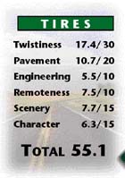
but manages an above the cut TIRES showing. This Remote route north of Hwy 12
initially follows the course of the Touchet River, weaving gently but
determinedly through hayfields, back and forth across the river. It then moves
away from the river and beelines across Eureka Flat, interrupting the
straightaway to do a little jog east down Hwy 124. The straightaway resumes
north of Eureka until the landscape undulates, creating sweeper-filled hollows
and gullies. The overwhelming dryness of the terrain — more intense the
further north you go — is strangely alluring. But the best Scenery comes on
the descent into the Snake River Coulee and on the straight stretch north
through Devils Canyon where deep brown basalt cliffs are set off dramatically
against a background of straw-colored rye grass. How do you find all this?
It’s easy, Dot. Just follow the gray paved road.