At a Glance
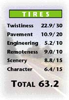
The Road Less Traveled can be an elusive find, at
least if asphalt is a prerequisite. So it’s time to get off your
meditation cushion and onto the Corbin when you find a highway posting
these kind of TIRES numbers with virtually no traffic. Turning off at one
lonely intersection of Hwy 101 and reconnecting at another, this parallel
route’s main reason for being is to provide access to that spiritual
retreat otherwise known as the Olympic Correctional Center. With open
straights and long, gentle curves at the northern end providing fine views
of the mountains and ridges of Olympic National Park and tight twisties
dominating the thickly treed south, this quiet road strikes a harmonious
balance. While we can’t guarantee you’ll discover your inner self here,
you shouldn’t discover many discordant speed tax collectors, since this
road is under the care of the mellow National Forest Service. Everyone
breathe together now: Intake. Exhaust. Intake. Exhaust.
Access
From Hwy 101
North Access (mid-DH20 Forks - Kalaloch)
Look for the well-marked turnoff east onto the Hoh-Clearwater Road. Take
it. You’re on the road.
South Access
Take the turnoff north to Clearwater. You’re on the road.
On The Road
Sightlines aren’t an issue on the handful of long,
gentle sweepers that start you out from the DH’s northern junction with Hwy
101. While you’re running a gauntlet of thick trees, they are set well back
from the wide bed of pavement. The first of many logging signs is revealed
in the patch of obvious reforestation on the left side of the road at 1.6 mi
(2.5 km). As you straighten along a plateau here, you maintain a view of
snowy Mt Olympus in the distance.
The straightaway is ended by a sweeper at 2.6 mi (4.2 km), but it’s quickly
followed after a few turns by another of similar length. Heading southeast
now, the road begins curving more, albeit gently, beginning at 4.6 mi (7.3
km). The scenery is pleasing, too. As you edge ever so slightly along the
bottom slopes of Mt Octopus, the blue lines of Matheny Ridge come clearly
into view.
Did you check out TE-A Upper Hoh Rd before hitting the
DH? If you left your
copy of Destination Highways Washington sitting on the counter of the Hoh
Rain Forest Visitor Center’s gift shop, you can retrieve it by turning off
onto Owl Creek Rd at 6.9 mi (11.1 km) and taking this partly graveled
shortcut back to TE-A. Not that you’d know that without the book, of course.
The roadway continues south, with well-separated curves taking you through
thick trees. This being the Olympic Peninsula, there’s been some serious
cutting at 9.6 mi (15.4 km), though it’s surprising there isn’t more of it.
You cross the Snahapish River before a 45-mph (70-kmh) posted limit, a
straightaway and a sign mark the entrance to the grounds of the Olympic
Corrections Center at 11.2 mi (18.0 km). A prison in the middle of a DH.
Maybe those National Forest Service STCs aren’t so mellow after all.
The trees are tight and thick and so are the curves as you drop into the
Snahapish River Valley at 12.0 mi (19.4 km). There are a few surprises, such
as some spots of rough asphalt in the blind corners, or the one-lane bridge
crossing the river at 16.1 mi (25.9 km), but with the road’s best twisties,
you don’t mind giving a little on the pavement and engineering.
The great esses end once you’re over the Snahapish. But if you want to set
up camp close to them, no problem. The turnoff to the DH’s easiest access
camping, Coppermine Bottom BCG, is at 16.5 mi (26.6 km).
A couple of short straightaways intervene before the next set of corners
arrive. At 18.4 mi (29.6 km), the road twists, turns and crosses a bridge
over Christmas Creek, flowing invisibly beneath the thick underbrush. The
road surface is rougher and seems narrower too, due to the overgrown
shoulder and overhanging trees. These twisties aren’t as good a gift as the
earlier series either, being fewer, sweepier and more detached. Having said
that, they sure beat a lump of coal. Hoh Hoh Ho....
After another short straightaway, the road crosses the high, one-lane bridge
over the Clearwater River at 20.3 mi (32.6 km). From here, the path curves
gently, and fairly consistently, but there’s just too much straightness to
suggest it parallels the course of the river, winding unseen somewhere
beyond the trees to the right.
At 25.5 mi (41.1 km), the road narrows suddenly and dramatically and the
pavement drops in quality, just as you enter the settlement of Clearwater.
No services here, unless you count the Sheriff’s Office. If you’re in luck,
his car’s there.
It takes a while to clear Clearwater, as its handful of houses are strewn
along the road with no apparent interest in observing the city limits,
assuming there are any. It doesn’t matter much as the road’s pretty straight
here anyway, not really curving again until it winds toward and then along
the bank of the Clearwater River at 28.2 mi (45.3 km). Someone obviously
wanted to use up some extra budget money on the southern tip of this road,
as evidenced by the deluxe bridge over the final crossing of the river.
The
DH’s final act closes at 29.7 mi (47.8 km) at the stop sign marking the
intersection with Hwy 101.
Twisted Edges
TE-A Upper Hoh Rd (18.0 mi / 28.9 km)
Winding, blind-cornered, and often polluted with pylons, the spectacular
moss-dripping rainforest for the last six miles is the main draw on this
TE. For this, you’d pay the toll. You sure ain’t paying for the
engineering.
ROUTING OPTION: On the way out, maxburners can avoid doubling back all the
way to Hwy 101 by taking the Owl Creek Rd connection to the DH.
TE-B South Shore Rd (7.9 mi / 12.7 km)
Enjoy your meal at one of Lake Quinault’s finer restaurants? This scenic
route along the lake and out into the forest and farmland is a quiet,
after-dinner toodle. If you really want to challenge your digestive
system, you can continue onto the gravel and loop back via the North Shore
Road. Belch.
|
|
|
|